FUNCTIONAL AND SCALABLE NETWORK SOLUTIONS.
GEOSPATIAL
Improve all facets of network asset management.
Geospatial Services
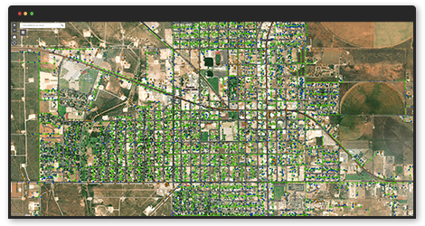
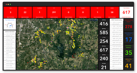
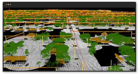
Empact's proprietary data collection and analysis approach allows us to update and correct all asset locations, pole records, feature details, and attachments. We are also able to run advanced vegetation analysis for entire systems or select areas of interest. Utilizing this approach allows us to deliver highly accurate data and analysis much faster than legacy methods of data collection. Through EMPACT's extensive analytic and remote sensing experience, we are setting the standard in remote sensing in the utilities domain through growing availability of geospatial data that helps utilities more dynamically and cost-effectively manage their networks.
To maintain a functional and scalable network, utilities are faced with the challenge of varying environments, customer service, cost management, and maintaining the reliability of existing infrastructure. EMPACT utilizes geospatial technology, such as lidar, and big data analytics to improve all facets of network asset management.
EMPACT’S PROCESSES CAN BE LEVERAGED FOR VARIOUS USE CASES
- Asset Management Inventory
- PLS-CADD Modeling
- Conflation
- Substation Mapping
- Vegetation Management
- Growth rate prediction
- Pole Lean Analysis
- Digital Elevation Modeling
- Corridor Modeling, Design, and Maintenance
BENEFITS OF EMPACT'S APPROACH
- Rapid, accurate survey of overhead conductors, wires, and poles
- Complete inventory of conductors, transformers, SCADA devices, poles, etc.
- Accurate mapping of as-built infrastructure
- Accurate and rapid identification of obstructions
- Rapid joint-use audit